Sunday, August 20, 2023

Comings and Goings

Hi All,


Sorry that it's been awhile between posts on my blog... the thing is I've been out walking!


Having spent the best part of the last three months walking up in the north of the country it's become apparent to me that I'm not going to have time to try and knock out any kind of half decent blog post anymore. Now I'll never say never, however I'm thinking that from now on I'll probably be sticking mostly to my YouTube stuff (smash the subscribe and like buttons!).


I've also been posting some more current content on fb and insta if anyone wants to jump over there to check out what's been going on in my Feral world.


Finally, I'd like to thank the people that regularly logged onto this blog for the last 8 years - I always found it amazing that anybody would be the least bit interested in my fairly mundane adventures. When I was regularly posting the blog was generating well over a 1000 hits a week which was amazing!


Here's the link to my YouTube Vlog

Saturday, July 15, 2023

Pyramid Hill Circuit Walk - February 2023

I wasn't over run with crowds on this walk.

After setting off I climbed up a good track to a wide saddle.

Once up on the saddle it was time to attempt the scramble to the summit.

Just below the trig I had to traverse this ledge to get around some low cliffs.

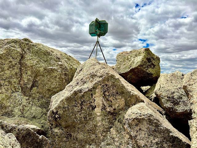
Pyramid Hill Trig.


The view from Pyramid Hill was surprisingly extensive.

Looking back down towards the Pyramid Hill township.


Pyramid Hill scrambling.

There were still a few wildflowers around.

It's fairly flat country in this bit of Victoria.

I finished the stroll off with a circumnavigation of the hill.

The Dirt. 
According to my AllTrails app I walked around 1.9 kilometres and climbed about 87 metres on this fairly easy walk. Now while I've called it easy, the scramble to the trig might put some people off as there is no formal track and the going is pretty rough. I climbed to the summit from a broad saddle that the circuit track passes through. I used my AllTrails App for this walk.

Relevant Posts.

YouTube Video.


Friday, July 14, 2023

Ferntree Falls, Two Mile Walk, Mt Buangor State Park - January 2023

I set off along Two Mile Track this afternoon. This little waterfall is an un-named one on Middle Creek.

I walked Two Mile Track in a counter clockwise direction.

Two Mile Track.


Two Mile Track climbs into the surrounding hills a bit...

...before swinging back towards Middle Creek and Ferntree Falls.

I'd jagged a stunner of a day for this walk.

The walking track network up in Mt Buangor State Park is very good.

The upper drop of Ferntree Falls.

I think the lower drop is the prettiest spot...?


Once leaving Ferntree Falls it was only a very short stroll back to the ute.


The Dirt.
According to my AllTrails App I walked around 3.0 kilometres and climbed about 157 metres on this easy walk. There is a nice picnic area at the car park (and a few other scattered through the park) as well as some camping spots. Ferntree Falls can be visited without completing the whole walk by just walking the route clockwise from the car park. In my experience the walking track system up here is top notch and normally well maintained. I used my AllTrails app for the walk this afternoon.

Relevant Posts.

YouTube Video.


Thursday, July 13, 2023

Torrens Linear Track Circuit - January 2023


I decided to start this stroll outside the St Peter's Cathedral. 

Heading down towards the Torrens River I passed by The Oval Hotel where Sam and I were staying  on this visit. 

Once I reached the Torrens River I swung west along the south bank through the parklands. 

The Adelaide Oval looming over the river.

The pedestrian bridge links the CBD to the sporting precinct.


As you've probably guessed by the number of dodgy photos I was quite impressed with the look of the bridge!

The Torrens River has some private school rowing pavilions lining it's banks.

It didn't take long before the walk took on a more rural feel.

I crossed over the weir and started my walk back towards the Adelaide Oval.


Someone had pulled the 'Millard' up at the riverside flats - things are pretty low key over in Adelaide!

Hmm.... I'm back at the pedestrian bridge again 🙄


Looking back towards the CBD from the north bank.

Heading back to the hotel - that's me done for the day.

The Dirt.
According to my AllTrails App I walked around 3.7 kilometres and climbed about 39 metres on this easy stroll. This walk is predominantly along sealed shared paths so I'm thinking that it would be ok for prams and wheelchairs. This is yet another of those walks that probably isn't worth travelling a great distance to do, however if you find yourself in the vicinity with an hour or two to spare then it's worth stretching your legs on this stroll. This was a version of a walk that I found on AllTrails.

Relevant Posts.

YouTube Video.


W had a great view of St Peter's Cathedral from our room.

Saturday, July 1, 2023

Kangaroo Gap & Alison Saddle Walk - December 2022

Setting off towards Kangaroo Gap - we were lucky on this trip to see so much water about what is normally a very dry area.

Red Gums.

Kangaroo Gap & Alison Saddle Walk - Rawnsley Park Station.

The walking was extremely easy as I followed a shallow valley south (ish).

This old Cypress Pine has seen a bit over the years I'm thinking.

That's Alison Saddle in the middle distance with Rawnsley Bluff poking it's head out in the distance. 

To complete the circuit I walked a nice ridgeline just on sunset.

Looking across Rawnsley Park to the outside walls of Wilpena Pound.


Rawnsley Bluff from the ridgeline.


I was dropping down to one of those white roofed buildings in the middle distance.


The Dirt.
According to my AllTrails App I walked around 5 kilometres and climbed about 158 metres on what I'd call an easy grade walk. This is another walk that is on Rawnsley Park Station so I'm thinking that you'd need to be staying there to walk it, the maps are available at reception. I did the walk at the back end of a stinking hot summer day and I'd highly recommend not doing this walk in the middle of a hot day - sunset and sunrise are best for views and wildlife anyway. I used my AllTrails map along with the mud map from the resort.

Relevant Posts.

YouTube Video.


Pelion Hut to Mt Ossa return, Overland Track - April 2010

Mt Oakleigh from the Pelion Hut heli pad. I think the mountain just visible in the mist in the distance is Cradle Mountain... ... the flat t...