I've had a young bloke from England staying and working with me for a couple of months. Dan is the son of a lady that I walked with in Patagonia, Bernadette. Dan is doing the whole see the world back packing thing that a lot of people do in their early twenties, with our time working and living together almost at an end I realised that as yet I hadn't managed to get Dan out in the bush with me, so with both of us free and a Saturday that the weather looked promising I thought I'd take him down and introduce him to my 'backyard' Wilsons Promontory National Park. After an early start, and a quick stop to check out some kangaroo's we were ready to hit the trail before 10 am.
 |
Dan checking out the native wildlife.
|
 |
 |
| This one had an itchy tummy. |
|
Parking at the Norman Bay car park at Tidal River I had a loose plan to head over to Bishop Peak and then come back to the ute via a couple of different tracks. With Dan being about six foot thirteen and with a stride to match, I figured that he may get a little frustrated at my sloth lake pace, it turns out that we weren't to badly matched although there may be a lot of photo's of Dan's back as he strode ahead whilst I took photo's (sorry Bernadette!). Leaving the car we headed up Tidal River a little till we found the bridge over the river, the photo's from early in the day are fairly underwhelming as the day was still fairly overcast. After successfully crossing the river without getting wet feet we then headed up towards the Lilly Pilly Gully trail, the track slowly gaining height as it sidled the side of the small hill through the coastal heath.
 |
We're on our way, the bridge over Tidal River.
 |
| Looking back towards Tidal River as the track climbs to the Lilly Pilly car park. |
|
Passing through the car park that marks the start of the Lilly Pilly circuit we walked the circuit in a anti clockwise direction, I was able to show Dan the effects fires have on the bush, with the dryer sections re-vegetating and the wetter swampy sections not burn't. We took the time to walk the small duck boarded section through a section of remnant rainforest, a pretty little stream flowing through it provided an excuse for me to stop a take a couple of photo's. Leaving the rainforest we started to climb up into dryer forest, once again I was able to show Dan the effects of the weather on the land with a massive section of the hill having been washed away in the 2011 floods.
 |
Re growth on the Lilly Pilly Gully walk.
 |
The beautiful creek that flows through the rainforest. |
 |
Dan, on the duck boarded section of the Lilly Pilly Gully walk.
 |
A scar left over from the floods of 2011.
|
|
|
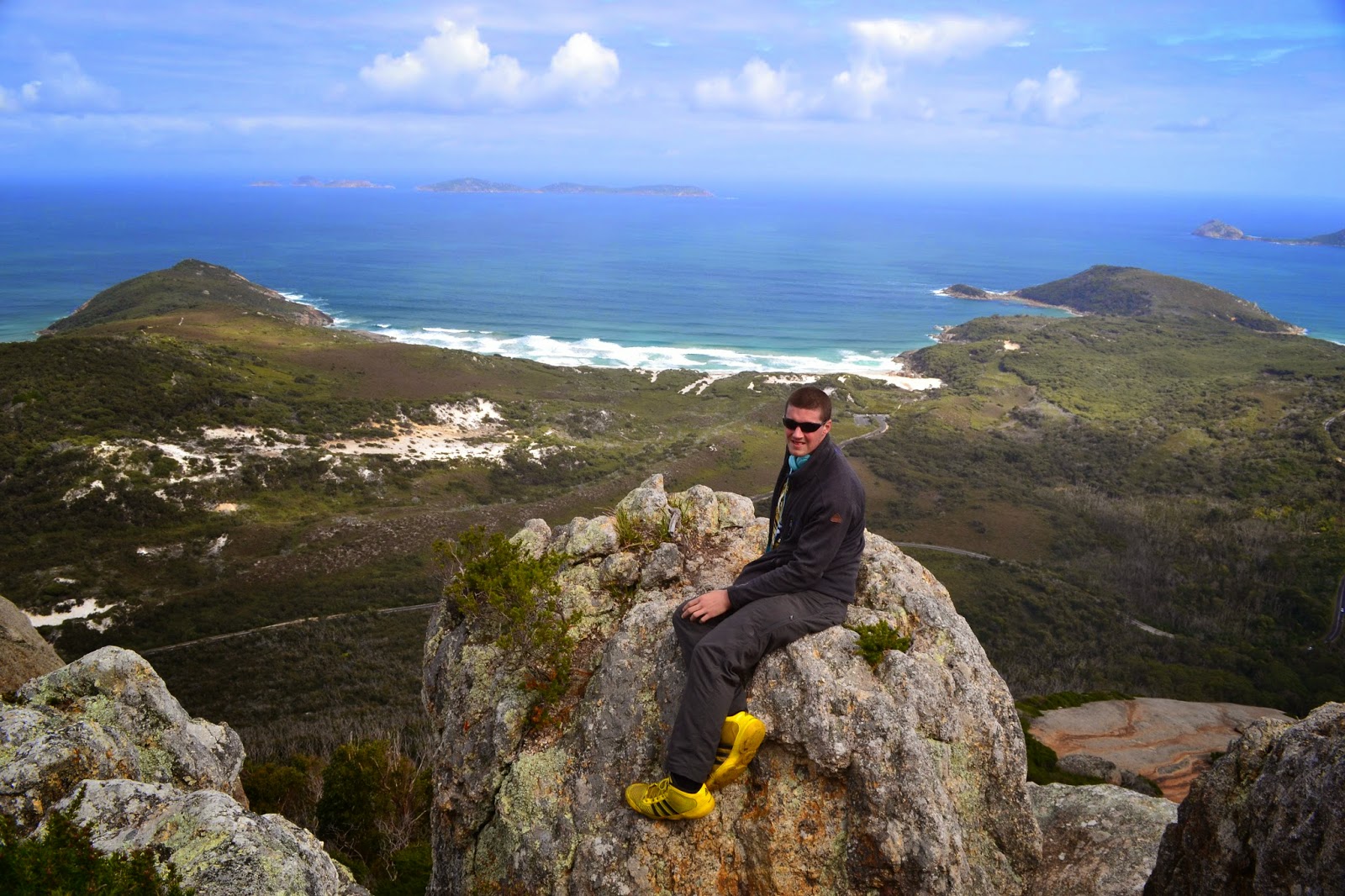
On reaching the track junction to Bishop Peak we started to climb a bit more, although in reality the climb was rarely more than gentle. Eventually we got to the top of the ridge and made our way out to the lookout at Bishop Peak. With the weather now fairly clear the view from here was quite good, with Tidal River and Mt Oberon dominating the view to the south, and Norman Island and the Glennie Group of islands dominating the view off shore.
 |
Bishop Peak.
|
After a bit of a break on top we headed back down to complete the Lilly Pilly circuit, quickly arriving at the car park where we had started the circuit. It was now around 1pm and with Dan needing to be back in Melbourne in time for a night of clubbing we started to make our way back towards the ute at Norman Bay, instead of doing an exact retrace however we headed towards Tidal Overlook. This involved climbing up and over the granite headland that separates Leonard Bay and Norman Bay and involve a small climb through the massive boulders. Arriving at Tidal Overlook we took a few more photo's before continuing on the now sandy track to meet the track back down to Tidal River.
 |
Heading back towards Tidal River.
 |
Squeaky Beach from the Tidal Overlook track.
 |
There were plenty of wild flowers out on the heath lands.
 |
The view of Norman Bay from Tidal Overlook. |
 |
| Mount Oberon. |
|
|
|
We were now on the home stretch, the track contouring above the north bank of Tidal River as we made our way back towards the bridge. After getting a couple of more shots of the tannin stained
river we followed it down to its mouth at Norman Bay giving Dan the opportunity to take off his shoes and get the feeling of the soft sand between his toes. A quick look at the beach and we climbed back up to the ute and set off for the drive home, Dan quickly dropping off to sleep which hopefully left him well rested for his night of clubbing, I only had to get us home and then settle into a hot bath, not something that required a lot of energy.
 |
Heading back towards the ute.
 |
Tidal River.
 |
The tannin stained water.
|
|
|
The Dirt.
By combining the Lilly Pilly, Bishop Peak and Tidal Overlook walks we walked around 17.2 kilometres, we climbed around 534 metres in total. I'm sure these walks have notes describing them somewhere, but I just used the Wilsons Promontory Special Vicmap at 1:50,000.
Parks Victoria have a lot of information online, easily enough to do these walks without needing any other notes. I'd rate any of these trails as easy, by combining them all together I'd rate it as medium but only because of the length, the tracks themselves are well marked, maintained and signposted.
 |
Heading along the river towards Norman Bay.
 |
The tide was definitely on the way in. |
|
 |
| Norman Bay, with a ship on its way to Melbourne. |


No comments:
Post a Comment