I’ve been a
little busy recently writing up a ‘crazy guy’ journal about a recent multi day
walk in the Budawangs so my blog has been a little bit neglected. Saturday promised to be a great day for the
beach so I thought I’d head over to the Surf Coast and re do a walk that I’d
done two or three times before, basically walking from Bells Beach to Point
Addis along the coast and then completing the circuit on inland tracks. After checking out the tides I decided to
start at the car park on Point Addis Road just off the Great Ocean Road nice
and early, this meant I would get to the Jarosite Headland with the tide still
low enough to get around it.
 |
About thirty seconds after leaving the car.
 |
| The inland section of the walk followed the Surf Coast Walk. |
|
So, after
locking the car I was off by 8 am, now 8 am is a time I’m normally
contemplating my first coffee on most weekends but seeing that I had to get the
tides right, and also the fact that the temperature today was forecast to get
into the mid thirties I figured that the coffee and paper could wait until
after the walk. I’d gone around 100
metres however when I had a gear malfunction and I then spent the next thirty
minutes re attaching the chest strap on my pack, so much for my early start. I
walked the circuit clockwise from the car park at the top of Point Addis Road,
this meant an easy start as the wide track contoured along the top of the Ironbark
Basin in an easterly direction. Every now and again a break in the trees would
give me a glimpse of Bass Strait through the trees, apart from that it was
Ironbark forest and grass trees that had my immediate attention.
 |
Looking down Ironbark Basin towards Bass Strait,
 |
Ironbark trees.
 |
| A few grass trees along the track beside Jarosite Road. |
|
|
After 40
minutes the track came to Jarosite Road, the Surf Coast Walk which I was
following at this stage then headed straight down towards Bells Beach Southside
more or less parallel to the road. The
country through here consisted of low wind pruned coastal heath which allowed
plenty of views out to the ocean, eventually breaking out and following the
road for the last couple of hundred metres to the Southside car park. There
were a few surfers out this morning even though the swell was very small, after
getting a photo from the lookout of the surfers I headed down to beach level
and removed my boots, the next hour or so would be all sand.
 |
Heading down to Bells Beach Southside.
 |
Looking towards Point Addis from Southside.
 |
| Not much swell at Bells Beach today. |
|
|
The beach
along here to Point Addis featured soft cliffs, the soft clay erodes very
quickly causing large sections of the cliffs to fall to beach level, it’s not a
place to walk near the base of the cliffs, luckily with the tide fairly low and
the swell small there was plenty of room on the wide beach. The constant erosion
also gives the cliffs a fluted appearance, which along with the different coloured
clay, made for some good photos. The
walking on the firm sand was easy and with me spending time splashing along in
the shallows and taking lots of photo’s I didn't really notice the heat.
 |
| Plenty of firm sand made the walking along this section very pleasant. |
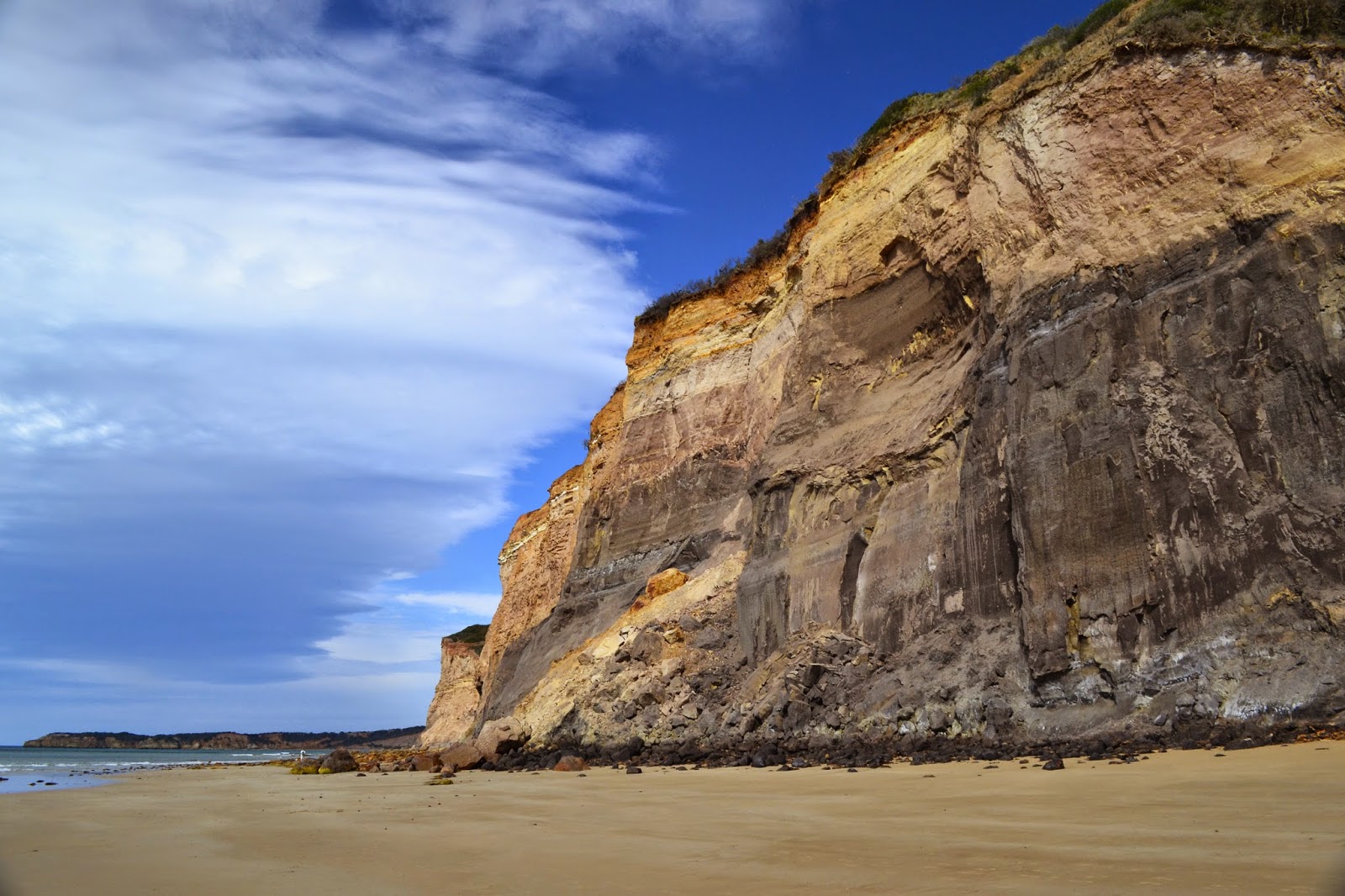 |
| Jarosite Headland. |
Rounding
Jarosite Headland I started to come across a few nudists, this is one of the
few legal nude beaches close to Melbourne. So when in Rome I stripped off and
went for a swim, it may have been a warm day but jeeze the water was cold, not
ideal for the ego when skinny dipping! After drip drying it was time to pull on
the shorts and head off again, I now headed along the length of Addiscott Beach,
a beautiful white sandy beach backed by a long line of cliffs. The Jarosite
Headland end of Addiscott beach appears to be the clothing optional end while
the Point Addis end is the family friendly end, in between there appears to be
around two kilometres of beautiful beach that is no man’s land.
 |
Rounding Jarosite Headland onto Addiscott Beach.

 |
| Addiscott Beach, with Point Addis in the distance. |
|
Arriving at
the beach access steps near Point Addis I put the boots back on and attempted
the small side trip to Pixie Cove, unfortunately I’d obviously procrastinated
too long as the water was over the rock shelf stopping access to Pixie Cove
without my going for another swim. Oh well, I suppose that means I’ll have to
return and do it again one day. After my aborted attempt on Pixie Cove I
retraced my route back to the beach access track on Addiscote Beach, climbing
up the track the heat hit, the temperature climbing as I climbed the steps. By
the time I reached my turn off the temperature in the Tea Tree was well into
the 30’s.
 |
Point Addis.
 |
The cliffs around Point Addis.
 |
| This was as far around Point Addis I could get, Pixie Cove will have to wait for next time. |
|
|
Sweating
bullets I now followed the indigenous cultural walk that winds its way back
along the length of Addiscott Beach, this time on top of the cliffs. The cultural
walk has plenty of points of interest referring to how the indigenous lived off
the land, by now though it was getting too hot to linger in the scrub for long
so I pushed on to the first lookout on top of the cliffs. There are two or
three lookouts along this section of track and as well as providing great views
out to Bass Strait they also provided a bit of a breeze which took the edge off
the heat. The track drops to the lowest section of cliffs before turning
sharply to the north west and climbing back up to the car park at the top of
the Ironbark Basin, the climb is very easy, only the last ten minutes requiring
any real effort. Getting back to the car I jumped in and cranked up the air
conditioner, the temperature read out in the car showing the outside
temperature as 36 C, I love summer!
 |
On the indigenous cultural walk above Addiscott Beach it was bloody hot.
 |
Looking along the length of Addiscott Beach towards Jarosite Headland.
 |
Point Addis.
 |
| Addiscott Beach, if you squint you may be able to see a couple of my nudist mates! |
|
|
|
The Dirt.
I walked around 12 kilometres and climbed 185 metres on this walk, I'd rate this as an easy walk. I used the notes from 40 Great Walks in Australia by Tyrone Thomas and Andrew Close although I did the walk in reverse and used a different start point than their notes described, due to the tides. Parks Victoria will no doubt have a map and notes online.
 |
| Heading back up Ironbark Basin towards the car. |
 |
| Time to get in and crank up the air conditioner. |


No comments:
Post a Comment