 |
In my grand tradition off wanting to go where everybody else isn't I decided to take Sam on a summer stroll along The Great South West Walk over Christmas in 2007. It did occur to me that maybe it wasn't the smartest thing I've ever done, asking Sam to trek for days in the summer heat, a fair chunk of it along a seemingly never ending beach that is renowned in walking circles for being a bit of a slog. What could possibly go wrong? Anyway that's how we found ourselves getting dropped off at the start of our stroll at Moleside Camp by one of the friends of the Great South West Walk.
 |
| Moleside Camp on the Glenelg River, our start point on this stroll. |
Day 1 Murrells Camp 25 kilometres
We had a fairly early start to the day today being on the track by 10am, as anyone knows who's read my blog that'a about 4 hours earlier than most of my start times. As it turned out it was good to get away early as the day was fairly warm and humid, although luckily the walking was fairly easy. The track today more or less followed the sluggish Glenelg River downstream, just because we were following the river however didn't mean that we had plenty of opportunities for swimming, as while the river could be seen tantalisingly close it was not very often that we could actually access the water. We were a couple of hot and sweaty walkers when we arrived at Murrells walkers camp in the late afternoon, after getting the tent up I checked out the access to the river, it was just doable for me but Sam wasn't keen.
 |
 |
| Murrells Camp. |
Day 2 Dry Creek Track Camp 17 kilometres 42 kilometres total.
Packing up this morning after a hot a sticky night my first objective for the day was to find somewhere we could both access the river for a swim. Pattersons Canoe Camp was our first opportunity to swim and we had an extended break there, doing a bit of swimming and catching up on some reading, the river here was very shallow though so it wasn't the best swim we've ever had. From here we continued to follow the Glenelg River downstream, the river had now cut itself a decent gorge and the views from the cliff top track were extensive and impressive. We were thinking of heading to Simpson Camp but with the hot a humid weather we found ourselves progressing slowly so when we arrived at a small deserted picnic ground near Dry Creek Track we decided to camp there, while not technically 'legal' it was a pleasant enough camp, with a picnic table, water tank and toilet.
 | ||||||||
Lunch on day 2 at Pattersons Canoe Camp, Sam doesn't look overly impressed!
|


Day 3 Nelson 10 kilometres 52 kilometres total.
Once again we awoke to a hot day, we had decided to see if we could get some accommodation in Nelson tonight to get a bit of a break from the heat, so with that in mind we were off early. The Glenelg River here does a large arc from heading west to south to eventually south east along this section of the walk, in the process the Great South West walk passes from Victoria to South Australia and then back to Victoria again. The river views continue along here with the small Donavons settlement in view on the other side of the river at one stage. The walking was fairly easy and we were making good time, the only glitch we had this morning was when we disturbed a reasonable sized Tiger Snake. Arriving in the small town of Nelson in a cloud of bush flies we managed to get a self contained room at the pub for the next two nights, we had suddenly gone from hot, sweaty and dusty to moving into a pub, life was good!
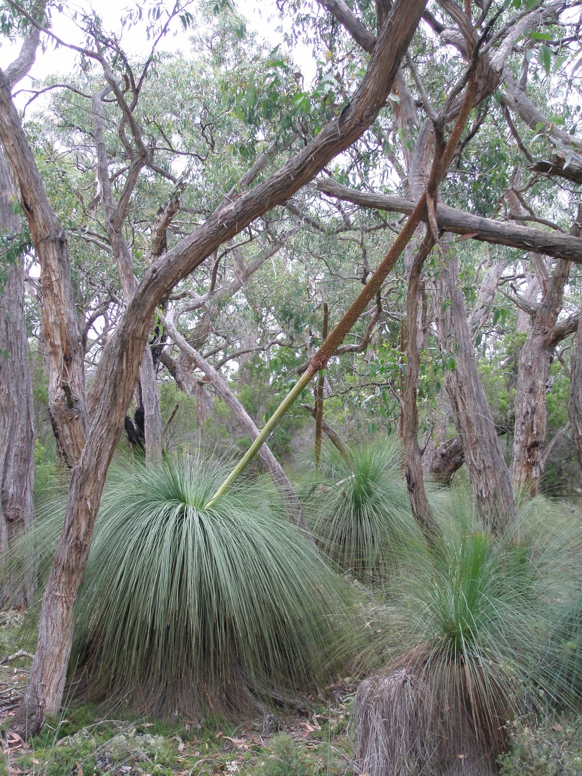 | ||||||||||||
The Great South West Walk past through a lot of Grass Trees on the way to Nelson today.
|


Day 4 Nelson 14 kilometres 66 kilometres total.
Sam decided on a rest day today, so I set off for a walk on my own. I decided to head out around the large Oxbow Lake to the Glenelg River opening on Discovery Bay. The aim was to tick off a small nature walk called the Livingston Island Nature Walk at the end of Beach Road, initially though I had a bit over 4 kilometres on bitumen, the combination of the hot temperatures and the hard surface gave my feet a hard time and after completing the 3 kilometre nature walk I was relieved to head out on Estuary Beach and take off my boots for awhile. The beautiful beach also was a great sheltered spot for a swim so I kicked back for awhile soaking my feet and catching up on some reading, at the same time trying to keep the massive blood sucking March Fly's at bay. Eventually I tired of swatting away the fly's so I set off around the estuary and onto the huge expanse of Discovery Bay and headed east until I picked up the Great South West Walk access track, glancing eastward into the salt haze the beach went on beyond my vision, that would be tomorrows challenge. Today I climbed back over the dunes to Beach Road and retraced my steps back to the pub, spending Christmas eve eating a nice meal with Sam in the relative comfort of our accommodation.
 | ||||||
Black Swans on the large Oxbow Lake near the mouth of the Glenelg River.
|


Day 5 Mombeong Camp 22 kilometres 88 kilometres total.
I'd done this beach section a couple of times before so I feared the worse for today, every time I'd walked sections of Discovery Bay before the sand had been incredibly soft and hard going, so with the ongoing high temperatures that we were experiencing I wasn't filled with a great deal of confidence on how we would go. We set off early and hit the sand before 9 am, luckily we had a receding tide with a wide hardish section of sand to walk on, my fears of a bit of a death march weren't going to be realised, we'll at least not today! We beach combed our way along the deserted coast, arriving at the old White Sands Camp for lunch. White Sands Camp has now been closed from what I hear, but back in 2007 it provided nice spot to spend the night, or in our case have some lunch. Leaving White Sand's the good sand walking continued until we climbed up onto the low cliffs at McEacherns Rocks, the walking along this section follows a low limestone plateau and it makes a pleasant change from the beach. Dropping back to the sand we continued to trudge on through the shimmering haze, eventually Cape Montesquieu started to materialise and with some relief we met the access track to the Lake Mombeong Camp. The walkers camp at Lake Mombeong is separate from the car campers and like every other camp on the Great South West Walk we were on our own, after a nice swim in the beautiful freshwater lake we were into the tent fairly early, tomorrow promised more of the same.
 | ||||
The seemingly endless beach of Discovery Bay from the access track near Nelson.
|


Day 6 Discovery Bay Beach Camp 24 kilometres 112 kilometres total.
Filling all our water bottles we headed back out to the sand early again today, the next water was 17 kilometres away at Swan Lake so I was pretty keen to get quite a few kilometres under our feet before it got too hot. Today we walked some very remote coast line, to make it seem even more wild and remote the vegetated dunes start to give way to bare dunes, there was basically no where to get out of the sun until we arrived at the 4wd infested Swan Lake. With dune buggies and 4wd's making a lot of noise around the camp we decided to fill our water bottles and continue on along the deserted beach. Back on the beach we continued on into the late afternoon, trudging along ever softer sand, eventually we had both had enough, so on finding a flat shelve on a dune we set up the tent with million dollar sea views. The cold water of Discovery Bay provided a nice tonic for tired muscles and after soaking them for awhile we retreated to the tent for dinner and another early night, what an magic night.
 | ||
Our Discovery Bay beach camp.
|

Day 7 The Springs Camp 15 kilometres 127 kilometres total.
Yeah, once again we awoke to bright blue and sunny skies it's all starting to sound the same, and once again we packed up and set off on another long beach walk. The difference today though over the last couple of days was that today we would actually reach the end of the beach that we'd been following for the last three days. Before we reached the refuge of the cliffs of Cape Duquesne though we had another couple of hours along the ever softening sand, eventually meeting a rock slab that affectively marked the end of the beach for us in the late morning. Climbing up the access track we savoured the different view, we now could see Lake Bridgewater close by and as we climbed higher onto the cape the ocean views became expansive. After a nice cliff top walk we arrived at the baking hot Springs Camp in the mid afternoon, putting up the tent we spent the next couple of hours trying to find somewhere to sit in the shade, there isn't a lot in the way of big trees at The Springs Camp so we found ourselves sitting under the coastal scrub trying to stay cool. By late afternoon the sting had gone out of the day and we enjoyed what would be our last night on the track, finishing off all our excess supplies.
 | ||||||
The sands getting pretty soft now as, with some relief we are about to finish our three days walking along Discovery Bay.
|


Day 8 Bridgewater Bay 10 kilometres 137 kilometres total.
Today was hot (what a surprise) but the walking was sublime, the Great South West Walk today followed the cliff line around Cape Duquesne and Cape Bridgewater. Apart from the constant stunning views we also walked through an interesting section of track that passed through a petrified forest of small limestone (I think) pinnacles. A little while after passing through the calcified forest we arrived at the high cliffs of Cape Bridgewater, way below we could see the local colony of seals basking on the rocks and in the middle distance the white sands of Bridgewater Bay were in view. Leaving the lookout at Cape Bridgewater we slowly descended down towards the kiosk at Bridgewater Bay, arriving at the crowded kiosk late in the morning was a bit of a shock after spending so many days on our own walking along deserted tracks. A quick call to Portland taxis, a cold drink later and we were on our way back to the Portland Police Station to pick up the car. Driving back to Melbourne that afternoon we copped rain almost all the way, it seemed like we'd timed our exit perfectly.
 | ||||
The Great South West Walk rounding Cape Duquesne.
|


The Dirt.
We used the notes and maps out of John Chapman's 'Bushwalking in Australia', to be honest that's probably all you need if you've got a modicum of navigational ability. Over the years I've done the whole Great South West Walk and its a good walk, in the publicity stakes it suffers a bit being a bit further down the coast than the heavily hyped Great Ocean Walk. The Great Ocean Walk also seems to soak up a lot of government funding whereas the Great South West Walk is more of a community based walk. The friends of The Great South West Walk have a web site that is very informative and they will go out of their way to help facilitate your walk. So there we have it, another walk that I want to go back and do again, hopefully next time I will complete it in one go and maybe I'll get some good photos at the same time.
 |


No comments:
Post a Comment