Like a lot of posts on my blog this is about a place that I've visited more than once over the years, in fact my first visit to this particular piece of Australia pre dated the actual road by quite a few years, well there was a road (of sorts) but the Mereenie Loop Road name hadn't yet been coined. My first visit years ago involved a lot of water, red mud, digging and a very late night arrival into Alice Springs, this trip in comparison was a lot tamer but still involved a bit of mud and water but thankfully no digging or late night arrivals.
 |
|
Things weren't looking that good initially though as when we arrived at Kings Canyon Resort we found that the Mereenie Loop Road was closed because of flooding, over the course of the next few days, while we were enjoying our visit to Watarrka National Park, the road dried out enough for the authorities to open it up to 4wd vehicles, all good then! So after purchasing our permit which is need because the road passes through aboriginal land, we motored out of Kings Canyon Resort and headed for Alice Springs.
 |
The roads open to 4wd's, we should be sweet.
 |
A classic desert scene, a dingo resting in the shade of a Desert Oak on our way out of Kings Canyon Resort.
|
|
Far from striking out directly towards Alice Springs though the MLR initially heads in the general direction of Broome before doubling back on itself and heading east just after it makes a short sharp ascent up a jump up around 30 kilometres from the resort. The MLR along here passes alongside the extreme western end of Watarrka National Park, Carmichael Crag at the extreme western end of the George Gill Range catching my eye and getting filed away into the dark recesses of my brain for future exploration (when I win the lottery, probably). The red dirt road ends for a while as the MLR climbs the jump up, the bitumen surface providing a brief respite from the corrugations.
 |
|
Once on top of the jump up we made the obligatory stop at the lookout, this spot provides the last look out at the George Gill Range in the distance with the undulating sand dune country in the fore ground. Leaving the lookout we were now heading in the general direction of Alice Springs, up until now we had been negotiating some small sections of mud and water but nothing to serious, as we drove on towards Alice though the road became a lot more demanding. The MLR was pretty corrugated on this trip but that's pretty normal, however it was also increasingly muddy in spots, so muddy that unfortunately I was to busy negotiating the mud that I didn't actually take any photos!
 |
The low smudge to the left of the photo is the extreme western end of the George Gill Range.
 |
The MLR climbs up this jump up via a series of switch backs.
|
|
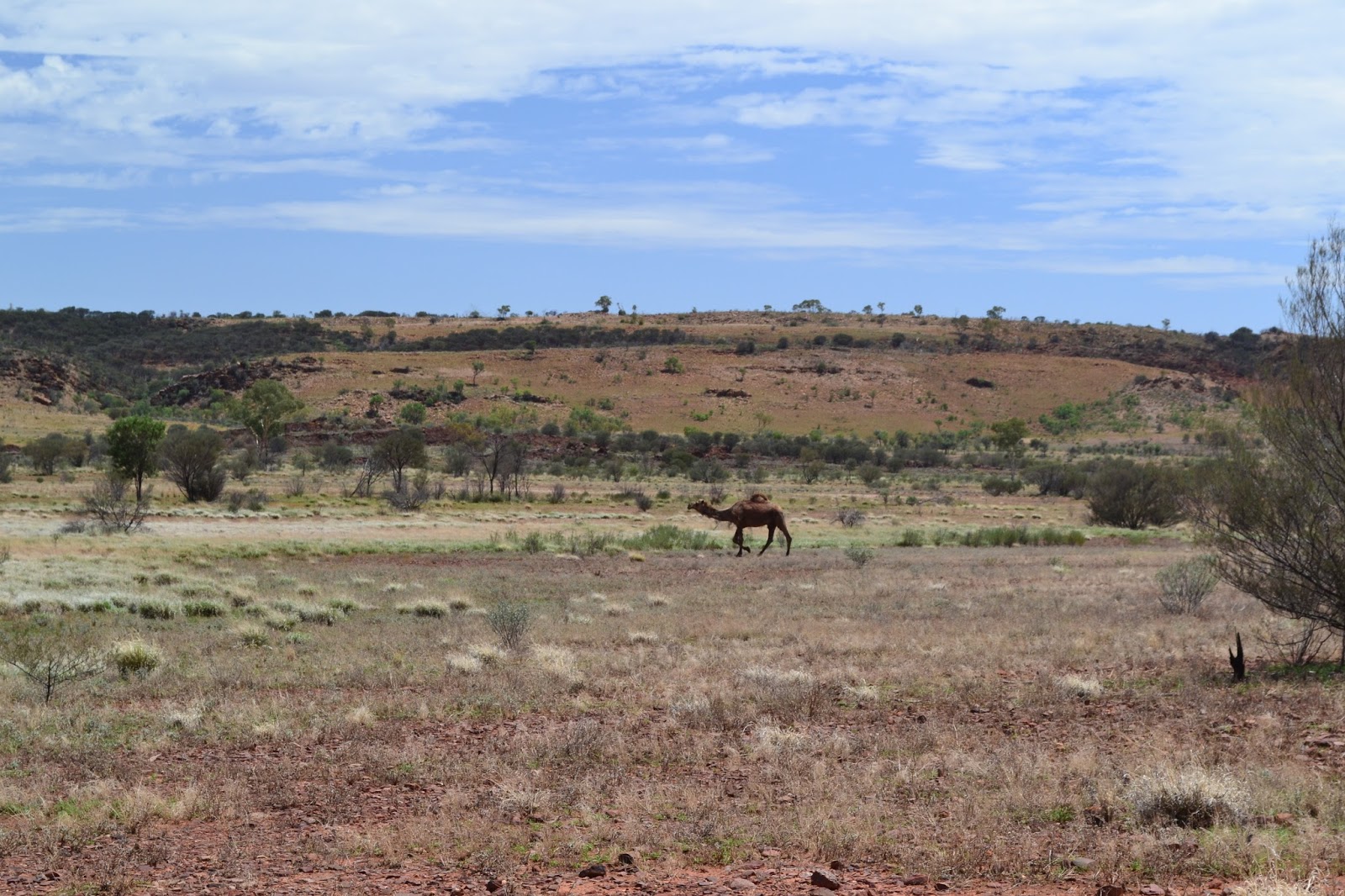
There was not a lot of traffic on the road either, we had been driving for around two hours and had only seen one other 4wd, so we were quite surprised when we crested a small rise to find a 4wd parked in the middle of the road and its occupants waving enthusiastically at us, it turned out that the French couple were a little nervous and were extremely happy to see us so they could follow us. So with our new French friends in tow and a few local camels watching on we continued our journey to Alice Springs.
 |
 |
| The desert was looking good after the recent rain, the camels must of liked the green grass.
|
|
Strangely enough one of my enduring memories of travelling the MLR was of some homemade signs at a particularly dodgy section of the road. The message "Lift Um Foot" has been painted onto the side of a 44 gallon drum and placed on the side of the road by some of the local indigenous people, it always makes me smile because that's the exact pronunciation that they would use if you were talking to them. Unfortunately the 44 placed at the other end that said "Puttum Back Down" had disappeared (I was later to find the missing 44 gallon drum at the Transport Hall of Fame in Alice Springs).
 |
Time to back off a bit.
 |
This was the signal to put the hammer back down again, unfortunately this drum now resides at the Transport Hall of Fame in Alice Springs instead of out on the MLR.
|
|
Passing the turnoff to Namatjira Drive which makes its way to Alice Springs via Glen Helen our new French friends headed off up the bitumen, we instead headed along Larapinta Drive via Hermannsburg. While the name may have changed the road hadn't, the mud, water and corrugations continuing for another 40 kilometres until we reached the one time home of the famous artist Albert Namatjira, Hermannsburg. The road into Alice Springs from Hermannsburg is bitumen all the way so I wasn't expecting too many difficulties, although crossing over the Fink River on the low level bridge at Hermannsburg and seeing the Fink River flowing a banka with the local aboriginal kids playing in it and half the road washed away gave me reason to pause. It was obvious that the low pressure system that had been hanging around the Northern Territory for most of our visit had dumped a fair bit of rain up here.
 |
There was a little water around.
|
Since leaving Hermannsburg I'd had a niggling concern floating around the dark recesses of my mind, why wasn't there any traffic around? Being the middle of summer the traffic drops off but I'd still expect to pass a few other people on this trip, especially as we were now back on the bitumen. Approaching Ellery Creek I realised why we hadn't seen to much traffic, there was a big road closed sign in the middle of the road, hmm. We were now around 100 kilometres from Alice Springs, if we had to back track it was a journey of at least 270 kilometres, assuming Namatjira Drive was actually open. Hoping that the sign was still there from the floods a few days earlier and just hadn't been removed yet I decided to push on, Ellery Creek was flowing over the road but didn't look too deep, a closer inspection showed that the surface of the floodway appeared intact so through we went. The water was around wheel height so didn't really cause any problems, stopping on the other side we got out to take a photo, the evidence of recent campfires still smouldering on the side of the road, some of the locals had obviously been stuck here for awhile.
 |
Ellery Creek, notice the yellow road closed sign on the entrance to the floodway.
 |
Luckily I'd worn my creek wading shoes on this drive.
|
|
Once across Ellery Creek we continued on towards Alice Springs, I was still little wary though as we had quite a few decent rivers and creeks to cross yet, including the Hugh River which had stopped me on other trips. Luckily it appears that the road closed sign was an oversight as, while we had a few sections that were washed away or with a little water over them there was nothing to worry about really. I was fairly glad to be on the bitumen however as the closer we got towards Alice Springs the worse the weather got, with the rain setting in by the time we got to town we would have been slipping and sliding on the red dirt.
 |
The weather was decidedly damp as we closed in on Alice Springs.
|
The Dirt.
The journey from Kings Canyon Resort to Alice Springs along the Mereenie Loop Road is around 320 kilometres if you go via Hermannsburg. In good conditions the drive will normally take 4 to 5 hours, depending on how many stops you take, if the conditions are a little dodgy the red dirt road could take a lot longer. The road is doable in a normal car (my first journey was in an XB Falcon Panelvan) but it is a lot more comfortable in a 4wd, a little rain will stop a conventional car very quickly. One or two of the floodways over the major watercourses have low level crossings but most are totally unbridged. The scenery consists of sand country along with the occasional rocky ridge, with a lot of Witchetty Bush and Desert Oak, all in all this soft adventure is a good taster for what travelling in the outback of Australia is all about.


No comments:
Post a Comment