 |
Looking across to Hooker Plateau and my ascent ridge.
 |
| This is looking back to the summit and across to the Hooker Plateau on my descent down to Cleve Cole Hut from near Hells Gap. |
|
I didn’t mention it in the last post but yesterday was actually only my third day on my AAWT adventure that I didn’t get any precipitation, considering that it was day 18 of my walk I figured that was a reasonable stat. Makes you wonder what it’s like in winter really, maybe I’ll find out one day when my work commitments ease off a bit? I had a fairly short day in front of me today so breakfast was a leisurely affair as I waited for the sun to reach this deep valley. While I didn’t get any rain I also didn’t get any wind, so the inside of my fly was wringing wet with condensation this morning. The relaxing start to the day gave me a bit of a chance to check out a bit more of Big River which was looking very nice this morning with a bit of dappled sunlight filtering through the trees.
 |
Big River cascading down next to my camp.
|
With everything packed up I wandered down the track around 15 metres before dropping all my gear again on the bank of Big River. Checking out the crossing I decided that the best plan of attack would be to strip off and tackle the crossing in my river sandals and not much else, thank god not too many people get down here as with the water lapping at that uncomfortable height, it wasn’t a good look! At least I could of blamed the cold water I suppose;) After successfully crossing with all my gear and dropping it in the sun on the grassy continuation of Big River Track, I had the dubious please of doing the crossing again as I went back over to retrieve my waterproof camera that I had set up to get some action shots. Ironically my last two crossing were a total waste of time as all the timer photos on the waterproof camera were that much out of focus that they were unusable anyway. After drip drying in the sun for a little bit I pulled on my smelly clothes and set off up towards Bogong Creek Saddle and my turn off up Quartz Ridge.
 |
Drip drying in the weak sunlight after a very chilly crossing.
 |
I climbed the continuation of Big River Track for fifteen minutes or so until I reached the turn off for Quartz Ridge.
 |
| The start of my climb up Quartz Ridge, I signed in after Tim Cope. |
|
|
Filling out the walker intentions book at the base of Quartz Ridge I was a little chuffed to notice that the walker before me in the book was
Tim Cope, who along with
Jon Muir, is a bit of an Australian adventure icon in my eyes. So now I was following in the footsteps of a bit of a legend, albeit about three days behind him. Of all the routes up Mt Bogong my favourite is probably Quartz Ridge, this spur climbs through some nice Snow Gum forest lower down before popping out of the trees and climbing the rest of the way towards the Hooker Plateau along what is sometimes a knife edged ridge line. To start off though I had to contour around the base of the ridge a little to where the pad picked up the crest, this short contouring section was actually the hardest walking of the day as the wind had bought down a few of the dead trees and deposited them across the pad. Thankfully by the time I met up with the little sign post marking the route down to Cairn Creek Hut the gymnastic walking through the fallen trees was over.
 |
The initial section of my climb up Quartz Spur involved a bit too much gymnastic walking for the Fat Feral Walker.
 |
| Hmmm, I've been here a few times over the years. The climbing is pretty good from here on. |
|
From the Cairn Creek Hut turn off the Quartz Ridge track stays fairly close to the crest of the ridge all the way to the tops. Like I’ve already mentioned the walk up here is very good (well, as good as climbing Victoria’s highest mountain with a 20 kg pack on my back could be!). The thing with Quartz Ridge is that the climb isn’t unrelenting, occasionally the pad will cross over a knoll and descend a bit into a high saddle, these spots giving my screaming leg muscles a bit of a breather. Some of the Snow Gums on Quartz Ridge survived the big fires as well, the living trees providing a stark contrast to the bleached white skeletons of the long dead ones. Climbing out of the trees I decided to head to Quartz Knob for lunch, although it was very slow going. The going was slow not because of the climbing though, I was slow because I was scrambling around the rocks checking out the rocky buttresses and long range views while giving my SD card a severe workout, it’s a wild old spot up here.
 |
Quartz Ridge is my favourite of all the routes up Mt Bogong.
 |
 |
Looking down towards Mt Beauty from Quartz Ridge.
 |
 |
| West Peak |
|
|
|
|
Today was quickly turning into one of those days that stay in your memory for ever, with a clearish sky and virtually no wind Quartz Knob was a very pleasant spot for lunch, well except for the armies of ants that seemed to magically appear every time I put my pack down, bit I digress… I spent lunch gazing down into the snowy abyss of Cairn Creek Gully on the almost precipitous southern slopes of Mt Bogong, now I say ‘almost’ as the slopes are not quite vertical and are in fact the play area for some hardcore backcountry skiers every winter. Dropping off Quartz Knob I crossed a high, exposed saddle that I’d spent the night on years ago, with water from Bogong Creek it is possible to camp here but you need to be pretty sure about the weather.
 |
Approaching Quartz Knob on my climb up Quartz Spur.
 |
Cairn Creek Gully still had a fair bit of snow clinging to the steep terrain.
 |
To get to Cleve Cole Hut I'd be traversing this ridge line, arguably the most exposed walking in Victoria.
 |
Bogong Creek Falls were still partially covered by snow.
 |
| Looking across to Mt Bogong's West Peak, there is an off piste route off here down to Moncrief Gap Track that I'll get around to... one day. |
|
|
|
|
After the morning spent climbing I was starting to get a bit tired now as a contoured Hooker Plateau slightly to the south. The walk from here to the top of Mt Bogong follows a bit of an intermittent pad and the occasional decrepit snow pole, in fine weather like today it’s a no brainer but in the clag it’s a bit tougher. The thing with climbing Mt Bogong from this direction is that you can see the summit cairn for what seems like an eternity before you actually get to it, today was no different. Crossing the occasional late snow drift I seemingly inched my way across Black Saddle towards the summit of Mt Bogong, the deserted summit cairn slowly getting larger. It was along here that I started to notice something that would annoy me a bit for the rest of my AAWT walk, my left shoulder started to get a very sharp pain in the front of it (above my chest), the only way I could get any relief from this very sharp pain would be to stop and take my pack of for awhile. Over the rest of the walk I mucked around with different settings on my shoulder straps, as well as me carrying varying weights in my pack over lots of variable terrain but I could never totally shake the shoulder pain, although I seemed to settle it down a bit.
 |
Looking back down along QuartzRidge, it all looks pretty easy really, doesn't it?
 |
If you look closely you might see a few of the old snow poles sticking out of the snow drift.
 |
I managed to get close to some of the locals.
 |
 |
| I can see the summit cairn (mind you, it's that big you can probably see it from the moon!), but it always seems to take forever to reach it walking across here. |
|
|
|
|
Arriving at the summit of Mt Bogong was another milestone on my journey north, with Mt Bogong being the highest mountain in Victoria it would of been a shame to miss it and to be here on such a great day weather wise was the icing on the cake really. Dropping my pack it was time for an extended break now, the rocks near the large cairn making for a nice spot to sit and have a bite to eat whilst I dug out my phone to give Sam a call. After a bit of a break I wandered around the broad summit for awhile checking out the views stretching for many kilometres across receding blue mountain ranges and deep river valleys. After around an hour on the summit a build up of ugly looking black clouds hastened my exit a little, the section of track between the Mt Bogong summit and Cleve Cole Hut isn’t a spot you want to be in a thunder storm.
 |
 |
Is it just me or is that cairn getting further away?
 |
Mt Bogong, happy days!
 |
| Your Feral correspondent looking pretty happy for himself on Mt Bogong. |
|
|
|
I was now following the Hotham Bogong pole line again as I made my way across the exposed top towards the relative safety of the far off Snow Gums near Cleve Cole Hut. This section of today’s walk is a very popular section of walking track but I was happy to see it deserted today, it’s not that I’m anti-social it’s just that…..well actually, I’m anti-social! Crossing some more large snow drifts I was soon past the turn off’s to Staircase Spur and Eskdale Spur in quick succession, these are the most common ascent routes for Mt Bogong. Heading up a little out of Hell Gap towards Lendenfeld Point I was starting to actually wonder whether I was going to make it across this exposed section of track without getting caught, the black clouds were looking very serious indeed.
 |
That's Eskdale Spur in the middle distance....
 |
....and that's Staircase Spur below me.
 |
Following the pole line around to Cleve Cole Hut.
|
|
|
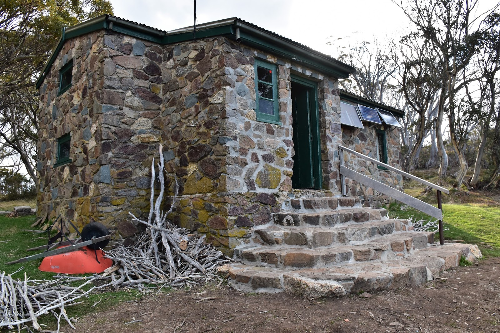
Passing over Tadgell Point the tree line came into view below me, it was only really now that I was comfortable that I’d make the hut before the storm arrived.
Cleve Cole Hut sits a little less than a kilometre inside the tree line near the ridge line, surrounded by beautiful Snow Gums and alpine grass meadows. This is a beautiful spot to camp, sunset and sun rises from around the hut are particularly photogenic. Shuffling down to the hut I noticed one tent, this was a good thing as this place can get a little busy. It turned out that the couple from the tent were planning to spend the night in the hut so for the first (and one of only a couple of times) on the AAWT I had the pleasure of sharing with others. Cleve Cole is a pretty big and luxurious hut as far as high country huts go, so we had a very comfortable and convivial night talking about past and future adventures and curing the ills of the world. Incidentally those black clouds that had hastened my departure from the tops never did deliver their load, so today became my fourth day on the AAWT without any form of precipitation.
 |
The weather was looking a little dodgy on my walk across to Cleve Cole Hut.
 |
Climbing a bit, heading over Lendenfeld Point.
 |
Dropping down towards the tree line... it looked like I'd dodge a bullet with the storms.
 |
| There are some big, old Snow Gums down here. |
|
|
|
The Dirt.
I walked 12 kilometres today and climbed 800 metres on another hard day. After 19 walking days on the AAWT my stats are 314 kilometres with 15,645 metres of ascent. Water is a little hard to come by today after leaving Big River Track and heading up Quartz Ridge, there is a good creek at the track junction but it’s best to carry enough to get from there to Cleve Cole. You can get water from the head waters of Bogong Creek off Hooker Plateau normally but its a reasonably descent and there is a bit of a spring near the old summit hut site on Mt Bogong but it’s pretty marginal sometimes. Camping is available in many spots, once again the options are only limited by the need for shelter and water, the surrounds of Cleve Cole Hut is probably the best option. Navigation today largely depends on the weather, in good conditions it’s no problems, in bad conditions the section from Quartz Knob to the summit cairn of Mt Bogong needs a lot of respect. The walking from Quartz Knob all the way around to Tadgell Point traverses probably Victoria’s most sustained exposed terrain, I’ve been up here in bad weather and it can be life threatening. I got a Telstra signal today from the summit of Mt Bogong as well as from slightly up the hill on the ridge line from Cleve Cole Hut. I used John Chapman’s notes and maps as well as Rooftop’s Bright - Dartmouth Adventure Map for an overview.
Relevant Posts.
AAWT, First day, October 2017.
AAWT, Previous day, November 17.
Mt Bogong Twice, Alpine National Park, 2016.
 |
The view from out the front of Cleve Cole Hut is pretty sweet.
 |
Cleve Cole Hut, tonight's accommodation.
 |
| Dusk from the grassy meadow next to the hut. |
|
|


Looks like a magnificent adventure! I long to return to the wilderness. To hell with this darned virus!
ReplyDeleteYes, I'll be pretty happy when things return to some kind of normal and we can head bush again!
Delete