Thursday, June 29, 2017

Little Waterloo Bay, Wilsons Promontory National Park - June 1995

Waterloo Bay is stunning stretch of sand, even in the middle of winter.
I've been in the Feral Way Back Machine again and after much grunting, squealing and smoke (and that was just from me as I perused the latest Mountain Design Catalogue) I emerged clasping these old photos. Yes it's time for another retro post. As usual I haven't got a lot to waffle on about on this stroll, we did this walk as a warm up for another bush walk that we had planned, now what the other walk was I've got no idea, but a stroll down to Little Waterloo Bay was a pretty sweet way to make sure all our gear was in good working condition.

Day 1     Telegraph Saddle to Little Waterloo Bay         10.2 kilometres
We left Melbourne fairly late in the day today so it was already after mid day when we pulled our packs on and headed away from Telegraph Saddle down the Lighthouse Track. Our walk down to Little Waterloo Bay was accompanied by the occasional shower passing through, but we stayed pretty dry for the most part. It doesn't really matter whether it's winter or summer, arriving onto the white sand of Waterloo Bay never looses wow factor I reckon, this stretch of sand is one of my favourite beaches in Australia, it's a shame that the water is so cold that swimming, even in there middle of summer, is generally a get in quick and get out even quicker affair. Arriving at camp we soon had the tent up and, after checking out Little Waterloo Bay and enjoying a nice dinner it was time to crawl in, thankfully all the gear, including the tent, was working well as we had a long and sometimes wet winters night ahead of us.
The duck board section that alongside Freshwater Creek was a magic spot.
Sam demonstrating her cat like agility as she leaps over Freshwater Creek.
There was a little wildlife around, even in winter.
Day 2    Little Waterloo Bay to Telegraph Saddle      10.2 kilometres      20.4 kilometres total
Next morning we crawled out of the tent, well rested after around 14 hours on our backs in the tent. Breakfast this morning was bacon and eggs, yes fresh eggs! I'd experimented with a plastic egg carrier and thankfully (for the insides of my pack) it had worked pretty well and all the eggs had made it down to Little Waterloo Bay in one piece. After packing up the tent we retraced yesterdays route back up to Telegraph Saddle, back when we did this walk the prom had yet to be decimated by fire and flood so we had the particularly enjoyable section from Waterloo Bay to the Telegraph Track to enjoy again, now days this bit of track is a pale shadow of what it used to be like, Sam use to call this section the enchanted forest. Once back on the Telegraph Track we put our heads down and arrived back at the troopie well before lunch time, while it may have been a short little break it's always great to get down to the prom and enjoy the fresh air.
Bacon and eggs for breakfast at Little Waterloo Bay, Feral indeed!
Early morning on Little Waterloo Beach.
We were heading up to the low saddle.
The Dirt.
We walked 20.4 over the two days on this easy overnight walk. Waterloo Bay has to be one of the prettiest beaches in Australia I think, it's a pity that the water temperature is generally always in single figures. The walk-in camps at Wilsons Promontory are (were?) very quiet over the cooler months of the year, on my many winter visits over the years I've spent many nights alone in empty or almost empty camps which makes a nice change from the warmer months. There is plenty of free stuff online if you want some extra information about this walk, a good place to start looking would be the Parks Vic site.
Relevant Posts.


Sunday, June 25, 2017

Corrigan Suspension Bridge and Forest Track, Tarra-Bulga National Park - June 2017

Descending Ash Track I got a few patches of blue sky peeking through the cloud.
I had some big plans for this Saturday, with forecast snow showers up in the high country I was going to head out on another serious high country ramble. Yep, that's what I was gunna do! The reality though was a little different, instead of leaping out of bed at 5am in the morning ready for another long drive up into the mountains, I turned over and went back to sleep. I surfaced a couple of hours later, but by now the high country was out of the question if I wanted to get home tonight. So now I was looking for something a little closer to home, wanting to walk somewhere that I've never written up before also thinned down the options a bit. Eventually I decided to head east down the Princess Highway to visit Tarra-Bulga National Park, this small national park (it's basically a small island of native flora and fauna surrounded by a sea of logging coupes) in the Strzelecki Ranges punches above it's weight when it comes to scenery in my opinion.
It was a little on the chilly side when I pulled into the car park this morning.
Now I might not of been heading up into the alpine country but Tarra-Bulga National Park is hardly at sea level, with the visitor centre at around 600 metres elevation it was a pretty chilly car park that I pulled into. After pulling on my boots and checking out the visitor centre, somewhat amazingly now days, it was actually staffed by a real person:) I headed off towards Corrigan Suspension Bridge, my first objective. Leaving the visitor centre car park, after a short section on Lyrebird Track I dropped down the extremely well constructed Ash Track towards the bridge. It's going to be a little hard to describe the bush in the park without sounding repetitive with my limited vocabulary (don't tell Mr Dutton but my english schooling finished at year 10), let's just say that there are a hundred shades of green in this park, all of them accentuated today by the frequent showers that were passing through. 
The Tarra-Bulga National Park visitor centre was open today and somewhat surprisingly, staffed.
I had to be pretty quick today to get photos when the sun came out, this is descending down Ash Track towards Corrigan Suspension Bridge.
Corrigan Suspension Bridge was originally built in 1938 as a tourist attraction to help the intrepid punters of the time to get a good view of the surrounding rainforest, although the current bridge was built by the army in 1982. At about the same time as I started to get some views of the bridge through the trees I also started getting pretty wet, the rain having set in a bit it was a pretty hit and miss affair trying to get a decent photo of the bridge without getting my camera wet. I must of made a pretty forlorn sight standing optimistically at the lookout waiting for the rain to pass so I could get a photo, eventually I decided that close enough is good enough (some very unkind people have suggested that this applies to my blog as well) and managed to snap off a couple of shots without drowning the DSLR. 
Your Feral photographer stood in the rain for twenty minutes waiting to get this shot, some might say with some justification, that I need to get a life!

Crossing the bridge I climbed up Scenic Track which initially passed through very wet cool temperate rainforest before climbing onto a ridge top and passing through slightly drier country. I was now completing a loop that would take me back down to the Bulga Picnic Area, the last section along the quiet bitumen access road. After passing through the empty picnic area I descended down the wide track to meet up with my outward route, Ash Track above the bridge. With that little loop complete I climbed back up Ash Track, stopping for awhile to watch a lyrebird scratch around in the damp leaf litter on the forest floor. Somewhat coincidently I soon turned onto Lyrebird Track, heading off into a slightly more remote and less visited part of the park. Lyrebird Track descends gently past a nice lookout through some slightly drier forest before coming to a picnic table at the junction with Forest Track, a sign warning walkers that the track from here promised to get a bit rougher under foot.
Climbing Scenic Track (its name and its outlook) I passed out of the cool temperate rainforest into the drier mountain ash forest.
Wondering down the access road to Bulga Picnic Area the road allowed me to easily take in the dripping forest.
Lyrebird
My walk today initially headed down to the left before I returned and headed off onto the slightly more remote Forest Track.
There is a nice lookout on Lyrebird Track that gives you a good view of tree ferns with the towering mountain ash behind.
Forest Track initially drops steadily into a very wet gully where the track crosses a tributary of Macks Creek on some duck boarding before starting a fairly long climb up to the junction with the Old Yarram-Balook Road. Forest Track was indeed a little rougher than the paths that had come before but really it was a pretty straight forward walk, the main issue I suppose was that the surface was a little on the slippery side, but you've got to expect that in a rainforest I reckon. It was on my steady climb up to Old Yarram-Bulook Road that the rain set in enough to finally convince me that it was time to stash the DSLR away in it's dry bag, pulling out my waterproof camera the photos for the rest of the walk suffered a little, but at least they had (the somewhat intangible) atmosphere instead.
Forest Track was the roughest walking of the day, but it was pretty easy really.
I've got a new camera - but it hasn't helped my macro shots!

Forest Track drops down to cross this tributary of Macks Creek on some duck boards.
By the time I topped out at Old Yarram-Balook Road the conditions were starting to close in a little bit, not that it mattered much as my walk now followed this old closed road so there were no navigational hazards to contend with. Old Yarram-Balook Road has been closed for a long time and now provides for a soft grassy walk, gently ascending to meet Bulga Park Road on the outskirts of Balook. The sleepy town of Balook was almost comatose on this rainy mid winters day, although I did notice that the local guest house and cafe were open for business, something that I filled away in my memory for when I eventually get back up here to walk some of the Grand Strzelecki Track. Ignoring the temptations of the cafe I instead headed back to the visitor centre, climbing into the ute to see that the temperature was still stubbornly refusing to climb above 5˚, ah yes, Victoria in winter.
Climbing up Forest Track towards Old Yarram-Balook Road the rain set in.


Old Yarram-Balook Road was very nice walking, even in the rain.
I've just arrived at Balook.
Balook is a very quiet and rustic little town.
The Dirt.
I walked 9.8 kilometres at an average speed of 3.5 kph today, with 262 metres of climbing I'd rate this as a easy walk. With the tracks all well sign posted and defined, the main issue today is probably the slippery and sometimes muddy surface of the Forest Track section of the walk, although in reality even Forest Track is pretty good as far as bushwalking tracks go. The Tarra-Bulga Visitor Centre has tables, a toilet and a BBQ and would make a very nice spot for a picnic and as I've mentioned the tiny town of Balook, a couple of minutes walk from the visitor centre, has a small cafe. Now on this walk I linked quite a few tracks together to create a decent length stroll, I used the free online stuff from Parks Vic to loosely plan my stroll. While no one as far as I know has written up this stroll as I walked it, John & Lyn Daly have written up some walks in the park in their old Take A Walk in Victoria's National Parks book.
Relevant Posts.
The last trail marker pointing me in the direction of the Tarra-Bulga Visitor Centre.
The Stzelecki Ranges are home to the long distance Grand Strzelecki Trail, this is another of those great little community run walking tracks, one that I'm definitely going to get back and support, even if it is only writing it up on my blog.

Thursday, June 22, 2017

Mount Cordeaux and Bare Rock, Main Range National Park - December 2008

The view back south along the tops of the Main Range from Bare Rock lookout, that's Mount Mitchell's East Peak poking up like a sharks fin.
Way back in 2008 Sam and decided to head up to Mackay to visit a couple of friends, to break the journey a bit we decided to spend a few days in Brisbane on the way. So not wanting to waste the journey and not get in a walk or two, I decided that I'd do the Mt Cordeaux and Bare Rock Walk on my way to Brisbane. I've probably been past the trail head at least 100 times over the years as I made my way on another journey to Brisbane with my old man in the truck, although with the trail head being at the top of Cunninghams Gap I was normally more focussed on us getting safely down off the range in the truck than I was on walking. Anyway with no such worries today it was time to head off and check out Mt Cordeaux.
The Allen Cunningham cairn above Cunninghams Gap.
Leaving the car park the track immediately climbs into thick rainforest and passes a memorial to Allen Cunningham who discovered the 755m pass in in the Main Range back in 1828. After checking out the old cairn I started my climb up through the thick green forest to Mt Cordeaux. Initially the sound of trucks grinding their way up or down towards Cunninghams Gap echoed through the trees, but as I slowly ascended the sound of the trucks gave way to the normal rainforest cacophony of birds along with all sorts of other hidden creatures that I could hear scurrying around. The climb up to Mt Cordeaux is pretty easy, well as easy as a climb of around 400 metres can be in the sub tropics anyway, the track is well defined, benched, and it gains height via some big lazy switchbacks (at least it did in 2008).
Climbing up through the rain forest, the track was pretty well graded.
Looking down to the Cunningham Highway from the lookout above Cunninghams Gap, I've travelled this road hundreds of times in trucks over the years.
The Cunningham Highway descending from Cunninghams Gap, Mount Mitchell's East Peak towering above like a sentinel.
Now my walk today didn't actually take me to the top of Mt Cordeaux, actually as far as I know there isn't a track to the summit. Instead I took a short side trip out to a lookout below the cliffs that protect the summit, the lookout not only giving my a close up look at the bulk of Mt Cordeaux towering above me, but also out over the fertile low country towards Brisbane as well as Mount Mitchell on the other side of the gap. 
For really good rainforest shots you need to check out Ms Extreme's blog.
The cliffs flanking Mount Cordeaux.
The author at the Mount Cordeaux lookout.
Mount Cordeaux from the lookout.
Leaving the Mount Cordeaux lookout I pushed on a bit (Sam was patiently waiting for me back at Cunninghams Gap), the trail now passes to the west of the Mount Cordeaux cliffs, descending a little to a high saddle in the rainforest before climbing once again fairly easily up to Bare Rock lookout. As the name would suggest Bare Rock lookout is an area of open rock, the lookout is just above the rainforest canopy and perched on the edge of the Scenic Rim so it provides a stunning view. Apart from the chance to see the distant high rise building of the Brisbane CBD glinting in the sun, the main interest is the view along the escarpment of the Scenic Rim, the sheer cliffs drawing the eye. After getting my breath back for a bit and taking it all in, it was time to retrace my route back to Cunninghams Gap and head into Brisbane.
The view north along the volcanic Scenic Rim from Bare Rock lookout.
Looking east from Bare Rock lookout.
The cliffs of the Scenic Rim.
The Dirt.
I walked around 11 kilometres and climbed around 450 metre on this medium grade stroll, those figures are taken from old guide books and maps however so maybe aren't the most accurate I've ever used. Speaking of old guide books I used the notes and mud maps out of Tyrone Thomas' old book, 50 Walks Coffs Harbour Gold Coast Hinterland. Now this book was published way back in 1993 and is long since out of print so you may struggle to locate a copy. The walk has since been also written up by the Daly's in their Take A Walk in South-East Queensland book and also as far as Mount Cordeaux by Melanie Ball in her Top Walks in Australia book. As far as it all goes Melanie's notes and maps are the best ones. This is a very good walk, the views from the tops, along with the rugged scenery make it a must do walk I think.
Relevant Posts.


The author at the Bare Rock lookout, I was pretty shattered with the summer humidity in Queensland after driving up from Melbourne the night before.

Sunday, June 18, 2017

Mordialloc & Carrum - June 2017

Looking out my lounge room window over the fog covered Wannakladdin Wetlands first thing this morning.
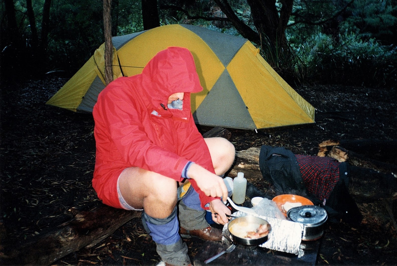
If there is anyone out there in blogger land who actually reads my waffle then they may have picked up that to keep a bit of pork off I ride my mountain bike to work most days. Now that normally entails a ride of just under 30 kilometres each day, with the good news being that it's almost completely on a bike track, even if it is a bit of a goat track in spots. Recently I was tootling home from work one afternoon with the soothing tunes of Sepultura bringing me down after another rich and rewarding day. Turning a corner a small cardboard sign caught my eye, doubling back to check it out I discovered that my path was going to be closed for a little while, while some remedial works were being carried out, yep my track was going to be closed from May to October! Fuck me, when they re-open it I hope it's paved with gold. Anyway there was some good news, the parks people had supplied a map that showed the possibility of a bypass for the closed section, the bad news is they suggested that if you did try and use the bypass route through an industrial estate then you will probably die - crushed under the wheels of a B double, so it's all good then. Your intrepid Feral commuter isn't deterred by minor technicalities though and I've been merrily dodging B doubles for the last month, you can't hear them coming when your listening to Rammstein anyway. So having been preparing for a bit of bike related carnage for awhile then, last week it happened. Thankfully I wasn't crushed under a 34 wheeled B double, no instead I stacked riding past a tree. Yep, my handlebar snagged a branch and at 5am on a frigid Melbourne winter morning I was suddenly concrete bound, with my feet clipped in there was nothing to break my fall, well except for my handlebar trying to pass through my thigh. Thankfully I was barely moving at the time and embarrassment was probably my biggest concern, luckily there aren't a lot of other punters around at 5am. Picking myself and my bike up I was relieved to see everything was pointing in the direction that it should be and I resumed my journey, happy to get to work and lick my wounds.
The end result of my commuting mishap.
So what's all that got to do with today's walk, well not much really except for the fact that I was lacking a little mojo when I woke up this Saturday. Staggering down stairs I looked out my lounge room window at the fog covered wetlands and decided that this week I was going to do a walk close to home. How close? Well I walked out my back gate and I was on the walk. Luckily for me Mr Chapman has actually written up some notes just to cater for me with his Mordialloc & Carrum walk passing by my house (actually Mr Thomas has also written up notes for another walk that passes within 100 metres of my front door). Wannakladdin Wetlands are part of the old Carrum-Carrum Swamp that once ran up and down parallel to Port Phillip Bay from around Mordialloc down to Frankston, the swamp was largely drained in 1879 by the construction of the Patterson River. Now days a lot of the old swamp is covered by houses but there are some reminders of what things use to be like in the form of the Edithvale Wetlands and Wannakladdin Wetlands.
Today's walk initially follows a series of these wetlands up to Mordialloc.

By the time I set off this morning the fog had more or less lifted and I was walking under perfect blue skies. After walking down the Patterson River for 100 metres I turned north towards Mordialloc along Long Beach Trail. To be honest this first section along the alignment of the Edithvale Wetlands is a little bit boring, sure there are a couple of lookouts over the wetlands but there are also long straight sections along the shared path, which needed all my Feral imagination to find much of interest to take photos of. Scenically things improved a bit when I got close to Mordialloc though and my route started to track along beside the Mordialloc Creek, this tidal creek is quite picturesque, especially in the weak winters sun. 
The lorikeet's were out and about tucking into the flowering gums, you'd almost think it was spring time.
Things were still on the chilly side first thing this morning.
Edithvale Wetlands
I was struggling a little to get interesting photos on the Long Beach Trail section of my stroll.
Once I arrived at Mordialloc Creek the scenery improved a little.
After refuelling in Mordialloc I shouldered my pack again and headed south, first crossing Mordialloc Creek before swinging down an almost hidden boardwalk besides the Bridge Hotel (quite a nice spot to sit on the deck and have a feed incidentally). After trying to get a half decent photo of the boats moored in Mordialloc Creek I headed to the beach. Once on the sand all I had to do was head south and keep walking until I reached the mouth of the Patterson River a few hours away. Now I may be a little disorganised but I did check the tides before I left home, you don't want to be walking this beach on a high tide. Consequently I wasn't surprised to find plenty of firm sand to walk on as I made my way south. On my journey south I amused myself trying to get a decent photo of one of the many boat sheds along this section of coast, but I was having a bit of trouble with all the little boat sheds seemingly backed up by ugly houses on the fore shore.
Mordialloc Creek provides a safe harbour for a colourful array of boats.
I've just arrived onto the shore of Port Phillip Bay, I now had an eight kilometres amble down the sand.
There are plenty of nice beach sheds along this stretch of the bay, but they are inevitably framed by fairly ugly houses.
Passing by the Chelsea Life Saving Club I came across a sight that is just wrong. I've made jokes before in relation to climate change and how we'll be able to sunbath in St Kilda in winter, well today I saw the real thing. Wandering along the beach I came across two couples lying on their towels in their bathers getting some rays, hmmm, so there you have it people are already sunbathing in Melbourne in the middle of winter. Not long after my encounter with the sun worshippers I arrived at the breakwater that marks the entrance to the Patterson River, turning up the river I was on the homeward stretch now.
Melbourne in winter beautiful one day perfect the next!
Now while it was a very nice winters day I'm not so sure about the whole sunbathing in winter thing!
I'm a little biased probably but I think the Patterson River section of the walk was probably the best section of todays stroll. Following a wide path up the north side of the river I was able to relax and take in all the activity on the water, from the flash boats heading out to Port Phillip Bay for a day out, the coast guard towing in a hapless boater or the many kayakers out on the water enjoying the weak sunshine, there was plenty happening along here. Getting closer to home the views up the river started to include the Dandenong Ranges in the distance, the distant ranges actually form the head waters of the river. Wandering past Wannakladdin Wetlands for the second time today the mornings fog was long gone, I tried taking a photo but was thwarted by bright sunlight, yep Melbourne in winter!
The Patterson River.
There are good shared use paths on both sides of the river along here.


I watched the Coast Guard tow this guy in while I was walking down the beach. I'm not sure if he'd just run out of fuel or if had been doing something wrong.
This one won't be heading out for awhile.
The Dirt.
I walked 20.3 kilometres at an average speed of 4.6 kph and climbed 88 metres on today's stroll. I'd rate this as a medium grade walk I suppose, although make sure you time the beach run for low tide as if you mess that up and find yourself trudging down 8 kilometres of soft sand then the grade would definitely be hard. Like I mentioned earlier I used some notes from the House of Chapman, this walk is out of their Day Walks Melbourne book. There are no real navigational issues on this walk so the map in the book is enough to get you through safely. There are plenty of choices if you want to eat out in Mordialloc and also in the suburbs that you pass by as you make your way down the beach, if you wanted to self cater then there are also plenty of nice picnic spots along the walk. This walk is really a walk of three parts, a parkland walk, a beach walk and then a river walk. While there is nothing drop dead stunning on the walk it's still a very pleasant way to get out and enjoy some fresh air and exercise. 
Relevant Posts.


Patterson Lakes
The Patterson River at Patterson Lakes, the blue smudge on the horizon is the Dandenong Ranges, my route to work follows this waterway for a large part of its length.

Pelion Hut to Mt Ossa return, Overland Track - April 2010

Mt Oakleigh from the Pelion Hut heli pad. I think the mountain just visible in the mist in the distance is Cradle Mountain... ... the flat t...