 |
|
Late last year an exciting event occurred in the feral house hold, I got myself a new walking guide book, yeah I read these guide books like some people read novels. It's nothing for me to read the same guide book cover to cover 5 or 6 times over the life of the book, I use it as form of escapism where by I imagine myself doing the walk described, using the description in the book to help me visualise the walk in my head. So picking up my new copy of Walking in the Otways from the house of Chapman I read it cover to cover and was looking forward to getting down there to do some walking, and then the fires started over Christmas, here we go again....... Now from what I can tell so far the fires in the Otways are no where near as bad as the still unfolding environmental tragedy in Tasmania, but they still roared through a lot of prime walking areas, which adds to the already large areas of Victoria that have been scorched in the last 10 years or so. So anyway with the need to drop some gear off to get fixed at Point Cook I decided to make the most of it and head down to the Great Ocean Road and christen my new book, not really knowing how many of the described walks have been effected I decided that I'd do a walk out of Anglesea, a fair way from what I believe was the main fire ground down at Wye River.
 |
| Anglesea Inlet. |
Parking the ute at the visitor centre in Angelsea I shouldered my pack and headed off to walk the imaginetively titled Anglesea Perimeter Walk-East. After walking around 200 metres of the route I was seduced into making the short detour into Angelsea to find a cafe for lunch, and that's where I stayed for the next couple of hours, eating, drinking coffee and reading The Saturday Paper, yeah I was doing it tough again. The good news is that while I re-caffeinated in town the mornings grey and overcast conditions started to brighten up a bit and by the time I re joined the route there were patches of blue sky appearing above. While I walked down the eastern side of the Anglesea Inlet I looked across the water to the visitor centre, this had to be a record even at my sloth like pace, two hours after leaving the ute and it was still in sight.
 |
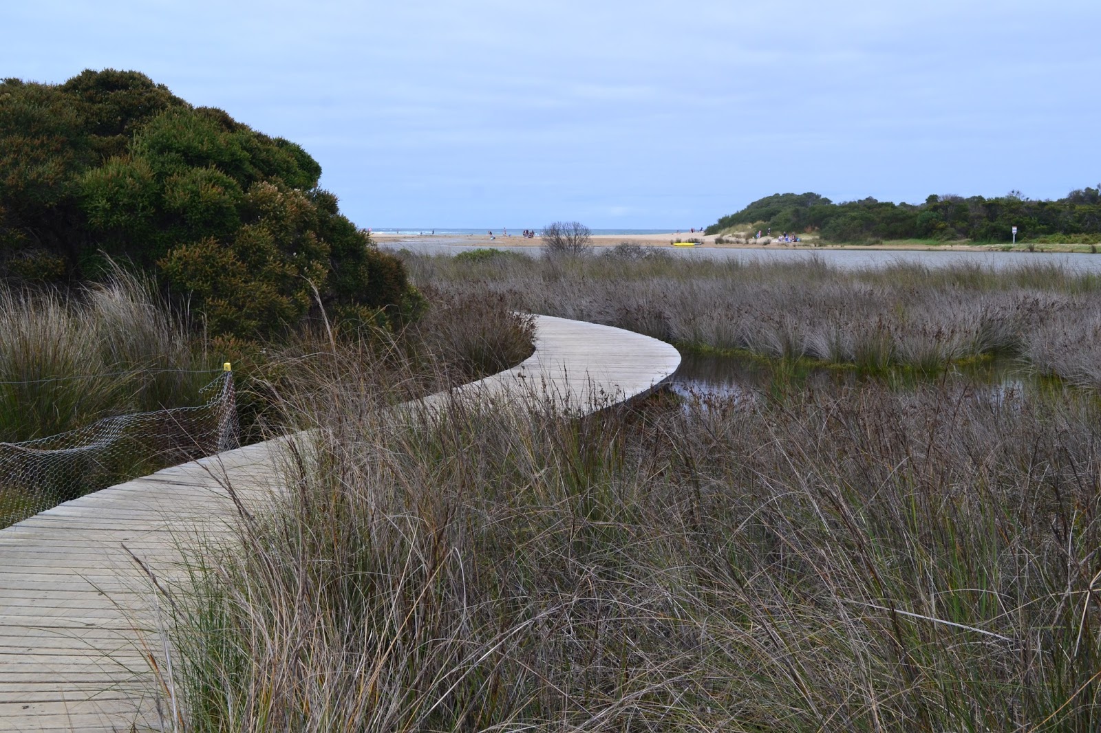
A salt marsh on the eastern side of the inlet.
|
The walk along the inlet to the beach was actually a pleasant walk with parts of the track a boardwalk over the salt marshes. With the mouth of the inlet closed off to the ocean the water level in the inlet was quite high, in fact in spots it was lapping at the edges of the track. While Anglesea is part of the Surf Coast the beach at Anglesea is actually fairly family friendly for a surf beach, and there were quite a few families out enjoying the late summer day. I didn't spend long on the beach though, turning east I climbed up the old concrete boat ramp almost straight away, heading inland towards the cliff top track. The cliff tops track passes along the border of the Anglesea Caravan and Camping Park, a place were I spent quite a bit of time in my younger years. Passing the back of the caravan park I met up with the cliff track, this track is part of the long distance Surf Coast Walk and its had a bit of money spent on it with a good surface and signage. Now on paper you'd imagine that this section would be one long feast of views, and indeed that's pretty much what it used to be like, but now the crumbling cliffs have been fenced off so that I couldn't actually get very close to the edge of the cliff tops, so what looked good on paper was actually fairly underwhelming in reality, oh well..
 |
Heading out to Anglesea Beach.
 |
The cliff top section of the walk heads along the top of these eroded cliffs.
 |
Tracking along between the Caravan Park and the cliffs.
 |
There is no danger of falling from the cliffs now days.
|
|
|
|
After a couple of kilometres my almost cliff side ramble ended and I headed inland climbing through Anglesea Heath, strangely while this bit of the walk didn't really appeal to me on paper the walking was a lot better than I expected on the ground. Even in late summer the heath had a few wildflowers out, and as I climbed higher up the dusty tracks the views that I'd hoped for from the cliffs started to open up along the coast. This is one walk that you need to keep an eye on your notes as the route takes its fairly convoluted route around town. Joining Don's Track I soon arrived at the highest lookout of the walk, 100 metres below me some of the locals were engaged in a friendly game of cricket on an oval, well friendly for Aussies anyway, I could still here the sledging up here!
 |
The cloud started to clear a bit as I climbed away from the coast.
 |
Looking out to Bass Strait from the lookout on Don's Track.
 |
| Anglesea with Point Roadknight in the distance. |
|
|
Dropping down Don's Track I passed behind the ovals and then climbed up and crossed the busy Great Ocean Road, the route now zig zagged its way into the low hills behind Anglesea through a mixture of heath land and dry eucalypt forests. I was now getting close to the old Anglesea power station and open cut mine. The power station was owned by Alcoa and used to provide cheap brown coal powered electricity to their aluminium smelter at Point Henry in Geelong. With the old smelter at Point Henry shutting down Alcoa had no need for the old power station and tried to off load it, unfortunately for Alcoa (but fortunately for the environment) no one was interested in buying a power station burning brown coal so the station was closed down on the 31st August 2015.
 |
 |
 |
| The Perimeter Walk has a short section beside the Great Ocean Road through these Radiata Pines. |
|
|
With the walk now featuring views of both the derelict power station and its accompanying open cut mine I was left to ponder who would pay for the rehabilitation of the site as I walked along beneath the power lines. We have an interesting public - private form of partnership happening in the mining industry in Australia, a partnership that I'm pretty sure most of the punters in Australia don't quite grasp, as for some reason the commercial media doesn't go near it.... Yeah the way it works is something like this, in Australia we privatise the profits from mining, and woe betide any government that tries to claw back a higher percentage of the profits from
our resources, the mining industry will pass the hat around and mobilise poor and downtrodden mine owners like Gina, Clive and Twiggy and run the mother of all scare campaigns to enlighten us all how they are only in it for the good of the country. The good news for those battling mine owners is that while the profits are most definitely privatised, the losses are socialised, yes quite often it's the tax payer that has to pick up the not insubstantial tab to rehabilitate the old mines, well you could knock me over with a feather but a lot of our fine upstanding corporate citizen miners have worked out that its a lot cheaper to walk away and forfeit their inadequate environmental bond than to actually rehabilitation the old mines. With over
50,000 old mines abandoned in Australia it seems as though this is actually a form of socialisation that appeals to the conservatives. At this stage we have to give Alcoa the benefit of the doubt and trust them as being good to their word when they say that they will rehabilitate the site, time will tell I suppose.
 |
 |
Black Wattle Track was probably the best walking on the track.
 |
| And Powerline Track probably the worst walking, that's the old power station and mine in the back ground. |
|
|
Anyway, after skirting around the power station I found myself on the banks of the Anglesea River again, all I had to do now was to follow it downstream to The Great Ocean Road. By now the cloud that had been slow to burn off was basically gone, so it was a slow amble down the wide lazy river. The Anglesea River has been the site of quite a few large
fish kills over the years and while in all probability its more to do with the mouth of the inlet closing up than it is the power station, it will still be interesting to see if the fish kills continue now the power station has closed. Today though the river was an idyllic location, there were kids swimming, people fishing and plenty of people on the calm water in their canoes. Soon after meeting the river I was walking through the outskirts of Anglesea, and after using the Great Ocean Road to cross the river I was quickly back at the visitor centre, in my ute and heading off home.
 |
Anglesea River.
|
The Dirt.
I walked 12 kilometres on this walk and climbed 160 metres. This easy walk has been written up by the Geelong Bushwalking Club and has
been edited and published by the Chapman's, its walk number 5 in the book. The walk was conceived and developed the environmental group ANGAIR and it takes the walker through an interesting cross section of the different eco systems around Anglesea. I actually only walked the eastern part of the Perimeter walk on this visit, there is an accompanying western section that I'll do at some stage. So if you find yourself down on the Surf Coast with 3 or 4 hours to kill this is a walk to consider, although I think it would probably be better in winter or spring.
 |
| Back at the Anglesea Visitor Centre, time to head home. |


No comments:
Post a Comment